-
 Polyunsaturated fatty acid
-
 Technical assessment
-
 Phoneme
-
 Confocal microscope
-
 Main sequence
-
 Gost
Gost
-
 Velcro
-
 Toluene
-
 Lateral chromatic aberration
-
 Capsule
-
 Eucalyptus
-
 Carcinoma
-
 True anomaly
-
 Pneumonia
-
 Pop-up
-
 Cath
Cath
-
 Somatic
-
 Coverts
-
 Ginkgo
-
 Function
-
 Vehicle occupancy rate
-
 Temperate evergreen forest
-
 GDP
GDP
-
 Cervical vertebra
-
 Black body
-
 Laparotomy
-
 Deimos
-
 Pierre Auger observatory
-
 Mean ecliptic for the date
-
 Ischaemia
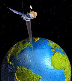
Altimetry
Altimetry is a satellite radar measurement which measures the distance between the satellite and the ocean surface to the nearest centimetre. The topography of the ocean surface and geostrophic currents can thus be deduced. Satellitealtimetry uses the time taken by a radar beam to make a satellite-surface round-trip, associated with a precise location of the satellite, to collect these measurements.

Altimetry is a satellite measurement. © educnet.education.fr
Latest
Fill out my online form.


